
I was cleaning out my desk draw at home, looking for the cable to charge my Garmin when I came across a cutting from a local paper. The story was about my Grandma and the party she had at her home to celebrate her 100th birthday. A huge milestone and a celebration of an inspiring and determined woman. Mary lost her husband shortly after I was born and having never remarried, lived on her own for a further 35 years. Following the bereavement she quickly had to learn how to manage money, something she had never had to do, support and raise a family and to get out there and work and be an active part of the community she loved. She simply kept going. She always there with a smile, always willing to help and do good and right by people – it is these things that will be my lasting memory of her.


So that was, in some way, a prologue to this blog which is about my favourite challenge in my year of challenges in aid of Make-A-Wish.
What is the National Three Peaks Challenge
The National Three Peaks Challenge takes place across the highest peaks in Scotland, England and Wales, totalling over 24 miles of walking and an ascent of more than 3,000 metres. The goal? To conquer Ben Nevis, Scafell Pike and Snowdon, all in just 24 hours.
My plan was to start at Ben Nevis at 5am and travel down the country and descend the last mountain, Snowdon, by 5am the following day. The reason for a 5am start was that it wouls mean the more technically challenging mountain, Scafell Pike, would be climbed in daylight, leaving only Snowdon to be climbed in full dark.
The Solo Three Peaks Challenge was a very special challenge for me, but in very in different ways. The Three Peaks Challenge is, for the British, a classic hiking adventure and something I had wanted to do as a teenager undertaking the Duke of Edinburgh Award scheme. There is something so inherently magical about the thought of climbing a mountain, a kind of daring mystery that reminds me of The Lost World by Sir Arthur Conan-Doyle. On reflection the ascent of Ben Nevis wasn’t too far from that memory.
The day before setting off for Ben Nevis my Gran, 1 week away from being 101, sadly passed away. While it was a call I knew was coming, it made it in no less upsetting. In the morning I set about getting on the road, a puncture delayed me by around an hour, but once sorted I made the slow, 9 hr drive to Fort William. I spent a large portion of the drive questioning if I should even be doing it and whether I should have just turned around to be with my family.
I exchanged a few text messages with my mum when I’d got to Fort William and she gave me the peace of mind I needed in order to carry on and complete the challenge. The last text ended “go do it 4 grandma”
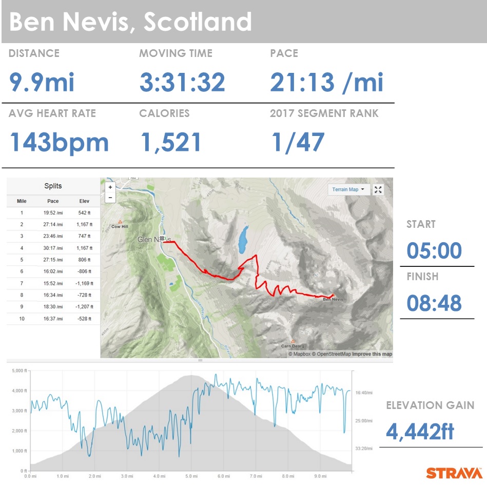
Ben Nevis – Scotland
Ben Nevis is an incredible 1,345 metres high, and it’s not only the highest of the challenge but the highest mountain in the British Isles.
There is really only one main route to the summit, however there are a couple of points from which to park and start your ascent. I started out from the Car Park at Glen Nevis Visitor Centre, crossing the Bridge over the River Nevis. This route provides an easier first half an hours walking over the alternative option which starts at the Youth Hostel. At 5am this gives the body a chance to warm in to the challenge, which I am sure you’ll agree is welcomed. The two routes meet after a while anyway so after this point the ascent is the same. The climb takes you up around Meall an t-Suidhe and the gradient steepens as you take the pass between Meall an t-Suidhe, with the Loch of the same name below to your left, and Ben Nevis. The Pony Track is largely well defined and stepped, making things easy navigationaly until you get closer to the summit. From the half way point the terrain turns to loose scree and the main path zigzags the rest of the way to the top. While walking this half way point I overtook a group of 3 lads also taking on the Three Peaks Challenge – we wished each other luck and off I pushed.

")
The higher I climbed the deeper in to the low clouds I went, meaning the zigzags and stone markers became increasingly difficult to spot without proper concentration. When you reach the summit you find the ruins of an observatory, a first world war memorial, an emergency shelter and a summit cairn with a trig point on top. Being shrouded in cloud and with only man made features on it the summit had an eerie, desolate feel. The cold wet fog, and therefore the lack of a view, didn’t keep me there for long so once the summit had been bagged I turned back. The descent is just the reverse, back down the Pony Track, the trick is I getting orientated to find the safest point to descent from.


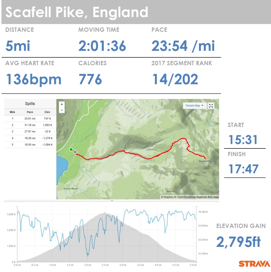
Scafell Pike – Cumbria, England
The drive down to Scafell Pike in Cumbria took a little longer than planned after taking a wrong turn on the way down through the Lake District to Wasdale. That said, I arrived at Wasdale Head car park in bright sunshine and to the welcome sight of quite a number of walkers, this being the more popular starting point.
The initial part of the ascent was very different to Ben Nevis, while well marked, the initial climb is much steeper and there are a number of more technically challenging aspects to the climb. At one point you cross over the mountain stream which feeds in to the Lingmell Gill below you – even in the day light you need to be prepared to get your feet wet, this would be a certainty in the dark or after a more serious down pour.


After a mile you will start to see the rocky outcrop that is Scafell Pike in front of you, forking off left at this point you start a more scrambling ascent over shattered rocks. The path is well marked with cairns but it would be quite easy to lose the path through a lack of concentration. The summit, once reached, is a huge expanse of scree with a trig point and a large stone cairn, shaped like a turret.
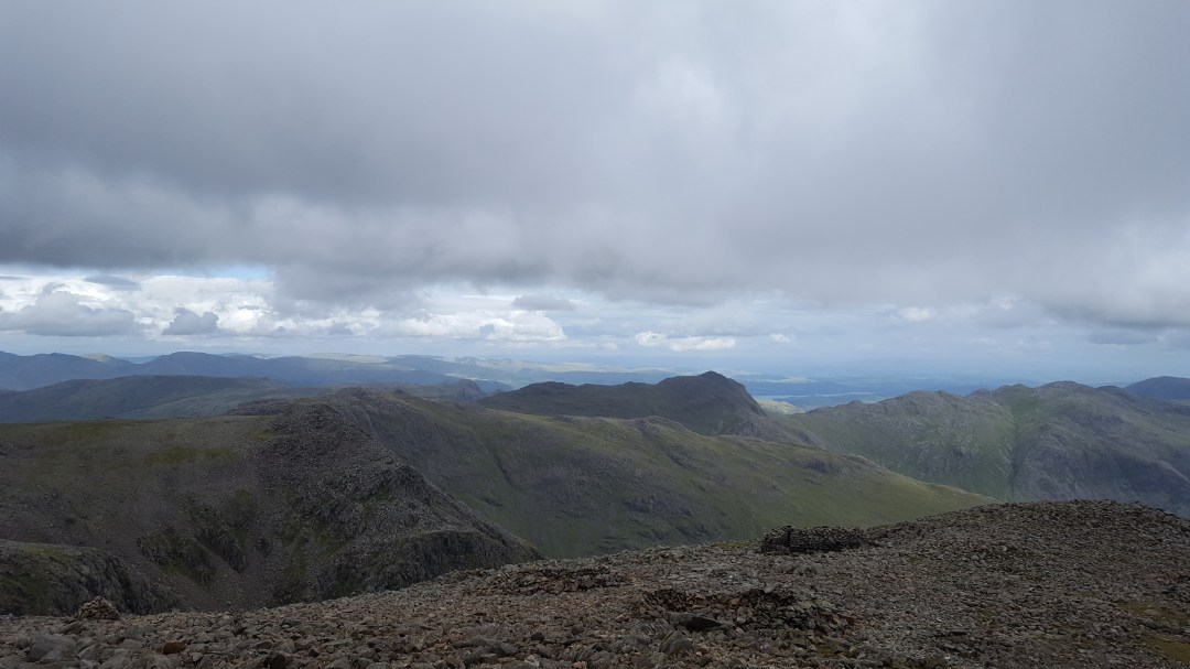
Although this is the smallest peak of the three, the views from the summit are incredible – on a clear day, such as the one I had, you have a panoramic view of the Lake District and even as far as Scotland and Wales. However I was so disorientated as to which direction I was facing at this point, I genuinely can’t tell you if I saw that far or not. While the sun was out the wind was whipping across the summit and was bitterly cold, so I took my obligatory photos and videos and made the same decent. The descent of Scafell was incredibly enjoyable as I found myself jogging down large sections, hopping between large stable rocks, enjoying the steeply angled but steep terrain.
I have to say how surprised I was on this climb to see so many people walking up or down in what I would have considered to be completely inappropriate clothing and footwear – I saw parents and children climbing in flip-flops…seriously!?
Snowdon – North Wales
Having researched the routes, before the challenge I had decided to take the Miners Track up to the summit of Snowdon and then descend via the Pyg Track. The Miners track, although a little longer it is flatter and as such I felt this would be preferable on the way up.
I started my ascent from the Pen-y-Pass car park at around 11:30pm. While the car park was full it was still clear in the pitch black I was going to be on my own for a while – there were a couple of groups of walkers who had just come down but no-one was going up alongside me. The Miners Track is wide and gravelled and as such easy to follow as it winds gently up and around the three lakes – Llyn Teyrn, Llyn Llydaw and Glaslyn at the base of the peak. Walking alongside these lakes and across the causeway over Lyn Llydaw was frankly a bit weird – the flat, black expanse of water is pretty foreboding when your on your own in the dead of night. In the dark it is easy to become disorientated as to where you are actually aiming for, the clouds hung on the summit there was no visual reference point so for most of the walk I was walking purely by map bearings.
The Miners Track ascends quickly around Glaslyn, and flattens out as you walk past the abandoned copper mines. From there is another steep section as you climb and join the Pyg Track, after which the path becomes less well defined due to the sheer number of rocks and large boulders. I found myself stopping often to check around me and relocate the path, having strayed sideways off it. A large upright stone half an hour from the top marks the join of the Pyg and Miners Track, which in the dark, was a welcome sight – both as I knew I was pretty damn close and that the way back down was quite going to be quite obvious.
From here you climb up to another ‘marker’ stone where you join the Llanberis path and along the 700m or so knife edge ridge which runs alongside the Snowdon Mountain Railway. This section is incredibly exposed and the wind and rain battered me as I walked, making the final stretch to the rocky summit hard work. The summit is marked by a stone cairn with a trig point, which is reached by two sets of stone stairs – for those climbing at a sensible hour there is a café just below you at this point – suffice to say there was no coffee for me. Snowdon was another summit shrouded in cloud and as such no night time view was there for me.
The decent is initially a repeat back down the Llanberis path, until you take the Pyg Track down at the marker stone after which you become sheltered again from the winds. The path is much narrower, and this first section is quite steep, and does require more concentration as you climb down large boulders and rock slabs. Unlike with the Miners Track this path is a pretty consistent descent, with very little flat sections. I meet a number of groups on my way down who were climbing up in order to enjoy the sunrise, which I had to agree with them would have been an amazing experience.
I finished the challenge just before 3am, well under the 24hr limit which was hugely satisfying. Having done all the walking and driving myself I was, as you can imagine shattered, so I folded my 6ft 4in frame on the back seat of my Peugeot and grabbed a couple of hours of broken sleep.

Final thoughts
While the emotions, coupled with the exertion and lack of sleep, made this a tough challenge it was need. Being alone gave me a lot of time to remember all of the good things about not just my Gran, but my extended family. Mary was, and I think will always be remembered as the matriarch of the Stapleford family, and annually she was the one thing that has kept drawing us back together. In July next year we’ll get together again and raise a glass to her, but for now – to Mary Hester Stapleford, that one was and will always be for you x
I put toghether a few clips from the challenge, which you can find here;

One thought on “My favorite challenge of 2017 – The National Three Peaks”